Geoscientific exploration
Geology
Horstberg
 Fig. 1: From the tectonic atlas of northern Germany (Baldschuhn et al., 1999)
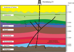
The location Horstberg Z1 is situated in the “Fassberg” inversion structure. The target horizon is the mid Triassic. Adjacent to Horstberg are the geologically relevant saliniferous structures Bahnsen, Dethlingen and Weesen-Luttherloh as well as the inversion structure Unterlüß. Close to the well bore Horstberg Z1 lies the Dreilingen Z1 well which confirms the statements form Horstberg.
Figure 1 shows a section of the map: “Structures in the subsurface of NW-Germany 1:500,000" (Baldschuhn et al. 1999). The red dashed circle outlines the area of interest. Saline structures are shown in blue, faults in red and inversion structures in green colour. One can see clearly, that inversion structures are a common feature across northern Germany.
 Fig. 2: The inversion structure Fassberg / Unterlüß
Figure 2 shows an N-S running cross section taken from the geotectonic Atlas (Baldschuhn et al. 2001) which runs almost perpendicular to the inversion structures “Fassberg” and “Unterlüß”. Therefore it can be used to clarify the geological structures. The cross section is based on the interpretation of non-migrated seismic data. The quality of this data is sufficient for a qualitative assessment but not satisfactory for a quantitative evaluation or high resolution of geological structures.
Geophysics – Seismic survey
Hannover
A seismic survey has been carried out at the location Hannover in order to determine the geological situation. The interpretation of this data shows undisturbed and horizontal layering. In cotrast to Horstberg there is a hiatus of the Tertiary cover and the upper Cretaceous. The target formation (mid Triassic) is estimated to be found at a depth of 3,400 m to 3,900 m.
Fracture location and monitoring during hydraulic stimulation
Further geophysical investigations will be performed in order to monitor and localize the artificial fracture during hydraulic stimulation actions. The goal is to determine the position and geometry of the fracture. Measuring methods will be monitoring of microseismicity, tilt measurements and spontaneous potential.


